Prospecting
Identifying a petroleum prospect involves various steps.
Geological mapping and geochemical surveys
A geological map can be complied from existing geological information and/or additional field work.
Geochemical surveys involve sampling rocks and soils and analysing these for mineral elements. The results can be mapped to show areas where concentrations of minerals may exist. 2167 In the marine environment, Underwater Remotely Operated Vehicles (ROVs) or submersibles and camera systems can also be used to capture a wide range of data, through both images and the collection of samples.
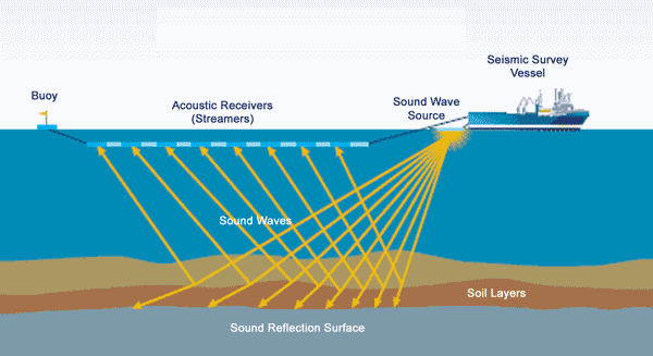
Seismic surveying
Seismic surveying allows data to be gathered over a large area about the geology of the subsurface (and the topography of the seafloor in the marine environment). Seismic surveying involves sending acoustic sound waves into the rock layers beneath the surface, and then recording the time it takes for each wave to bounce back to the measuring instrument, as well as measuring the strength of each returning wave. 2168 The various layers of rock reflect back different signals.
There are also other methods to obtain geophysical surveys including gravity surveys, magnetic surveys, electromagnetic surveys and radiometric surveys.
2169
-
http://www.pepanz.com/news-and-issues/issues/offshore-drilling/
-
http://www.nzpam.govt.nz/cms/iwi-communities/government-role/prospecting-and-exploration
Last updated at 2:06PM on February 11, 2018