Design Process
Identify
The first stage of good design is to develop an indepth understanding of the land. This is likely to take some time and require several technical studies and consultation with affected parties. It includes a full understanding of the following contexts:
- Wider physical context – the relationship between the site and the land backdrop, the coastline and other settlements
- Wider planning context – how the site is affected by council strategic objectives
- Tangata whenua context – the tangata whenua relationship with the land, historic and cultural sites, kaimoana resources and access linkages between marae, land and the sea
- Community context – the aspirations, issues and concerns of directly affected parties and the community more generally
- Immediate physical context – the geology, landforms, ecology, water and landscape characteristics of the site and any technical constraints such as vulnerability to coastal and other hazards, slope and stability
- Immediate planning context – planning provisions and controls which apply to the site
- Infrastructure needs – compatibility of the development with existing infrastructure
- Market context – likely buyers of the site and their preferences
This stage includes identifying sensitive areas and features of the site. A useful way to locate these areas spatially is through layering available information on a GIS platform. This enables the initial identification of areas which will not be suitable for development and areas which may be. Larger projects may require more sophisticated modelling in order to predict potential environmental effects.
Maintain and enhance
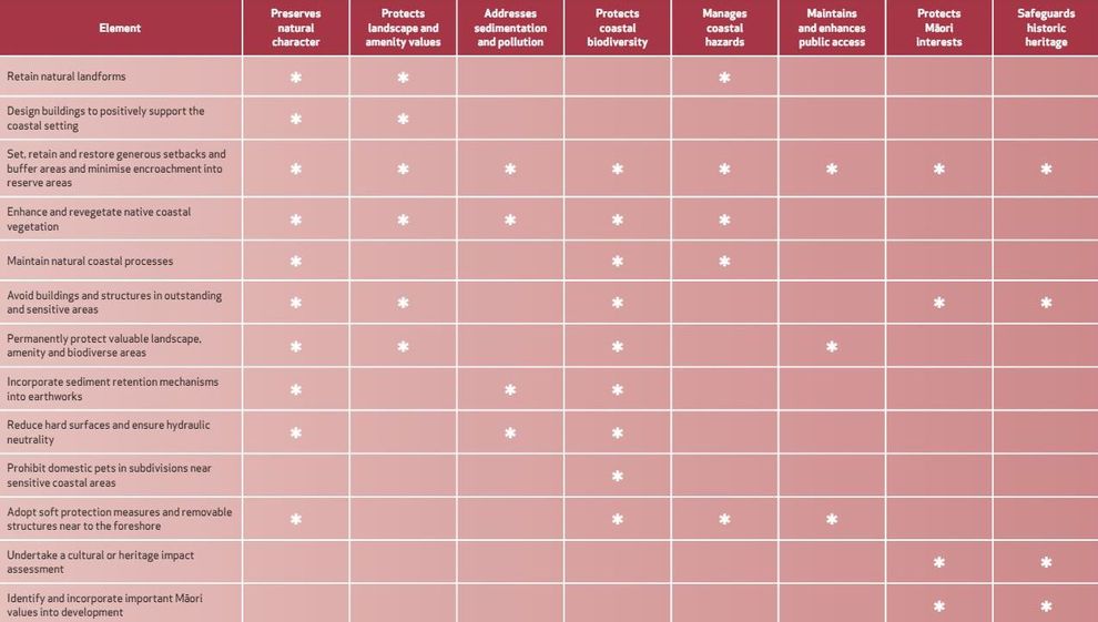
This stage includes identifying how the sensitive and important areas on the site can be enhanced through measures such as fencing, replanting and weed and pest control. Features which merit consideration for maintenance and enhancement include:
- Areas of outstanding natural character and outstanding natural landscapes – through avoiding development in these areas and legally protecting them to prevent future development
- Landscapes which contribute to amenity values and areas with high natural character – through avoiding intrusive development in these areas and legally protecting them to prevent future intrusive development
- Areas of significant indigenous vegetation and habitats – through minimising vegetation clearance, covenanting them to avoid future development and implementing effective weed and pest control measures
- Ecologically significant areas (such as the coastal edge, waterways, drainage areas and connective strips) – through minimising impacts on these areas and undertaking replanting and rehabilitation work
- Public access – through providing an effective means for members of the public to access the coast
- Areas of significance to iwi – through appropriately managing development in these areas and providing access to them for iwi
- Areas of cultural and historical significance – through avoiding development in these areas and permanently protecting them
Sensitive or important areas can be permanently protected by several mechanisms including:
- A restrictive covenant, which is registered on the certificate of title of the property, in favour of adjacent or nearby land
- A memorandum of encumbrance, which is a form of mortgage registered on the title of the property, and which creates a rent charge in favour of another party. This is not enforced if the landowner complies with a covenant not to subdivide the land. This can be used when there is no suitable adjacent land to receive the benefit of a restrictive covenant
- A conservation covenant under the Reserves Act, which can be used to preserve the natural environment or landscape amenity
- An open space covenant under the Queen Elizabeth II National Trust Act, which can be used to preserve a landscape of aesthetic, cultural, recreational, scientific, scenic or social interest or value
- A heritage covenant under the Historic Places Act, which can be used to protect an historic or wahi tapu place
- A consent notice under the Resource Management Act, which is imposed as a condition of subdivision consent and imposes legal obligations that can be registered on the certificate of title of the property
Create
The final step in applying a ‘best practice’ design approach is to create a coastal development which is sustainable in both the short and the long term. This is likely to include:
- Taking an innovative approach, both to the overall design and to the building form, which adopts both a New Zealand and local coastal style
- Reducing the bulk of the buildings and using natural and non-reflective materials and colours
- Using smaller house sites within wider covenanted areas and common land
- Keeping buildings and infrastructure well back from the coastal edge
- Keeping buildings and infrastructure off headlands and prominent ridgelines
- Maintaining and enhancing vegetation that can soften the effects of the development, and thus lessen impacts on the area’s natural character
- Incorporating sustainable engineering and building forms that minimise energy and water use and effectively manage waste
- Minimising the impacts of associated infrastructure through careful location (such as minimising cuttings required for roads and access ways), and using rural standards such as low or no street lighting, narrow roads and unpaved surfaces
- Future proofing the development, including access to it, from predicted sea level rise effects over at least 100 years
9fe96deb-f49c-456b-97c0-964a2913b0f0
-
Carter Holt Harvey HBU vs Tasman District Council EnvC 2013
Last updated at 2:12PM on February 25, 2015