New Zealand’s legislative history of providing for public access to the coast is complex. There never has been an absolute requirement for the protection of what is commonly referred to as the “Queen’s chain”, a strip of public land of about 20 metres wide along the coastline. But over the years, legislation has improved, and an esplanade reserve or strip is now usually created when land is subdivided into small lots for urban development. In addition, there are still many “paper” roads running to and along the coast which were surveyed off in the early days of European settlement, and many of these enable members of the public to access the coast.
The amount of land adjoining the sea that is currently held in public ownership varies between regions. It has been increasing over time as coastal land is subdivided and esplanade reserves or strips are created. However, even if coastal land is in public ownership, it does not necessarily always provide effective public access to the coastal edge for a variety of reasons. In recent decades, the surge in coastal development, the increasing popularity of rural-residential living, changes in land ownership and use, and advancing shorelines due to rising sea levels, have in some places impacted on the ability of the public to access the coastal edge.
Issues
There are a number of factors that are increasing the challenges faced by councils and other agencies in providing appropriate public access to the coastal environment. These include the increasing population, changes in land ownership, subdivision of rural coastal land, interventions required to manage coastal hazard risks and conflicts between coastal users. Provision of public access to the coast can be restricted by a number of issues outlined in the table below.
Type
Examples
Physical Barriers
• Barricades in the form of security gates • The inclusion of private roads within coastal subdivisions • The construction of seawalls leading to coastal squeeze at high tide • The construction of groynes • Erosion of esplanade and road reserves by coastal processes • Difficult terrain, such as very steep or rugged public land preventing access • Encroachment by landowners onto reserve areas in the form of private gardens and structures
Financial disincentives
• Costs for councils or landowners to manage and maintain reserves • Costs to comply with any health and safety requirements • Cost of compensation to landowners for purchase of high value coastal land as reserves
Other factors
• Restricting public access to protect natural resources and environmental values • Restricting public access to protect culturally sensitive areas and values • Loss of formal access when coastal farms are subdivided into lifestyle sections and campgrounds are developed • Changing ownership patterns and less desire by landowners to provide voluntary access • Lack of signage or information on where public access is available • Loss of publicly-available access facilities, such as camping grounds
One of the ways in which the RMA protects public access to and along the coast is through requiring the creation of esplanade reserves and esplanade strips on subdivision of land. When land is subdivided to create an allotment of less than four hectares, an esplanade reserve must be set aside along mean high water springs, along the bank of any river or along the margin of any lake,
d1c00af1-9a95-4df3-8877-eeea1937294d
unless a rule in a district plan or resource consent provides otherwise. The esplanade reserve must be 20 metres in width. Esplanade reserves are classified as reserves under the Reserves Act 1977 and land ownership is transferred to the territorial authority.
District councils retain the ability to waive this requirement or to reduce the width of the esplanade reserve required, through a rule in a district plan.
2dda5d89-6d2b-4fbb-a0be-8fd5449b596d
This discretion is expressly to be exercised “subject to Part 2” of the RMA and having regard to the purposes of esplanade reserves. District Councils can also require, through a rule in a district plan, that an esplanade reserve of a width greater than 20 metres be set aside, or that an esplanade reserve is required when allotments of four hectares or more are created. However, compensation must be paid for the extra land required.
Alternatively, district councils can include a rule in a district plan that requires, instead of an esplanade reserve, that an esplanade strip be created of a specified width. Esplanade strips are created by the registration of an instrument, agreed between the territorial authority and the subdividing owner, on the property title. Although this serves to protect the public interest in the strip, the land remains in private ownership.
Protect conservation values such as through maintaining or enhancing the natural functioning of the adjacent sea, river or lake, water quality, aquatic habitats and other natural values, as well as mitigating natural hazards
Enable public access to or along any sea, river or lake
Enable public recreational use where the use is compatible with conservation values
Key differences between esplanade reserves and strips are:
When an esplanade reserve is created, the reserve land is vested in the local authority, which manages the area. When an esplanade strip is created, ownership of the land is retained by the landowner and the public access right is registered on the certificate of title
Landowners can apply to vary or cancel an esplanade strip, whereas esplanade reserves cannot be varied or cancelled
Esplanade strips move with the location of high tide, whereas the width of esplanade reserves can be eroded by natural processes
Esplanade strips are often not marked on planning maps, so the public can be unaware of their presence, whereas esplanade reserves are marked and often promoted to the public
In addition to the RMA, the Local Government Act 1974, Reserves Act 1977, Conservation Act 1987, Walking Access Act 2008 and Marine and Coastal Area (Takutai Moana) Act 2011 offer tools to provide public access to and along the coast, including through mechanisms such as unformed legal roads, marginal strips, land covenants and setting aside of conservation areas. Access issues often traverse the administrative boundaries of different authorities, as well as private land. Effective management will often require an integrated approach that involves more than one agency and interventions through different statutory tools. While non-statutory tools can also be effective, legally defined access and access controls will be useful to provide certainty to users, landowners and managers.
The protection of public access to the coast is a central theme of the Marine and Coastal Area (Takutai Moana) Act 2011. The purpose of this Act is, in part, to “establish a durable scheme to ensure the protection of the legitimate interests of all New Zealanders in the marine and coastal area of New Zealand”. The Act recognises, through the protection of public rights of access, navigation and fishing, the importance of the common marine and coastal area. The legislation provides for the rights of individuals to access and engage in recreation in the marine and coastal area without charge. However, these rights are subject to any wāhi tapu conditions that might be set out in a customary marine title order or an agreement which may prohibit or restrict access to protect wāhi tapu or a wāhi tapu area.
The purpose of the Walking Access Act 2008 is to provide the New Zealand public with free, certain, enduring, and practical walking access to the outdoors, including around the coast, so that the public can enjoy the outdoors. The legislation establishes the New Zealand Walking Access Commission to manage this.
New Zealand Coastal Policy Statement
Protecting public access
Policy 19 of the NZCPS 2010 is the most relevant to public access. It recognises that members of the public have an expectation of, and need for, walking access along the coast that is practical, free of charge and safe. The Policy directs that local authorities should actively seek to enhance or restore public walking access to and along the coast. It identifies a number of examples where local authorities should specifically seek to achieve this. These include circumstances where:
Connections between existing public areas can be provided
Public access is threatened by erosion or sea level rise
Development of land adjacent to the coastal marine area has reduced public access
Improving access would assist outdoor recreation
Improved access can be provided for people with physical disabilities
Access is required to areas of historic or cultural significance
The Department of Conservation’s implementation guidance indicates that Policy 19 will require “positive implementation through policy statements, plans and decision-making”. This should result in more substantial and consistent provisions in plans to ensure on-going public walking access. It should also only see restrictions on public access applied after careful consideration. The Department of Conservation guidance provides some useful information about both regulatory and non-regulatory tools which can be used to maintain and enhance public access to coastal areas.
Public open space
Policy 18 of the NZPCS 2010 recognises the importance of public open space within and adjacent to the coastal marine area for public use and appreciation, including active and passive recreation. It requires provision to be made for public open space by:
Ensuring the location and treatment of public open space is compatible with natural character, natural landscape, natural feature, and amenity values of the coastal environment
Taking into account future needs for public open space within and adjacent to the coastal marine area
Maintaining and enhancing walking access linkages between public open space areas
Considering the impact of coastal processes and climate change so as not to compromise future access to public open space
Recognising the important role of esplanade reserves and strips in contributing towards meeting public open space needs
There are many factors that impact on the ability to provide public access to the coastal environment and it is important that access integrates well with, and does not impact on, the natural environment. Policy 18 recognises these drivers and directs councils to take a strategic approach to identifying future public open space and access needs.
Controlling vehicle access
Policy 20 of the NZCPS 2010 specifically controls the use of vehicles, apart from emergency vehicles, on beaches, the foreshore, the seabed and adjacent public land in circumstances where specified adverse effects may result. These include effects on the natural environment such as damage to dune systems and processes. It also includes harm to ecological systems or to indigenous flora and fauna, for example marine mammal and bird habitats or breeding areas and shellfish beds. In addition, vehicle access is to be controlled where there might be adverse effects on safety and cultural values, including danger to other beach users; disturbance of the peaceful enjoyment of the beach environment; damage to historic heritage; damage to the habitats of fisheries resources of significance to customary, commercial or recreational users; and damage to sites of significance to tangata whenua.
However the Policy requires identification of any areas where, and times when, recreational vehicular use on beaches, foreshore and seabed may be permitted without a likelihood of any of these effects occurring. Therefore the Policy prioritises environmental, safety and cultural concerns over recreational vehicle use on beaches. Where vehicular access is required for boat launching, or as the only practicable means of access to private property or public facilities, or for the operation of existing commercial activities, Policy 20 requires identification of such areas, and appropriate provision to be made for such access.
Protecting access to surf breaks
Policy 16 of the NZCPS 2010 identifies the need to protect nationally significant surf breaks by ensuring that activities do not adversely affect them and that other activities do not impact on the access to and use of the surf breaks. Seventeen locations of surf breaks of national significance are listed in Schedule 1. Policy 13(2)(c) and 15 are also relevant as surf breaks are part of the natural character of the coastal environment and are natural features within the seascape.
The NZCPS 2010 defines three terms:
“Surf break” is a natural feature that is comprised of swell, currents, water levels, seabed morphology, and wind. The hydrodynamic character of the ocean (swell, currents and water levels) combines with seabed morphology and winds to give rise to a “surfable wave”. A surf break includes the “swell corridor” through which the swell travels, and the morphology of the seabed of that wave corridor, through to the point where waves created by the swell dissipate and become non-surfable.
“Swell corridor” means the region offshore of a surf break where ocean swell travels and transforms to a “surfable wave”.
“Surfable wave” means a wave that can be caught and ridden by a surfer. Surfable waves have a wave breaking point that peels along the unbroken wave crest so that the surfer is propelled laterally along the wave crest
Surf breaks are finite resources and ad hoc reactive management risks the loss of these important resources. Surf breaks are surprisingly scarce. New Zealand has 18,000 kilometres of coastline but only 470 recognised surf spots and these places are unevenly distributed around the coastline. Surfing is an activity that is reliant on specific sites whereas other coastal activities are typically not so site-specific. Activities that threaten surf breaks include dredging for access to inner coastal areas and sedimentation.
The Department of Conservation notes in its implementation guidance for Policy 16 that the focus is on ensuring that activities in the coastal environment do not adversely affect surf breaks of national significance, or access to them and their use and enjoyment. The guidance directs councils to map the Schedule 1 surf breaks and swell corridors, for inclusion in resource management plans, along with protective provisions. Councils should also protect public access to surf breaks that are not specifically listed in the NZCPS 2010 but that have significance at a local or regional level.
Best practice planning elements
Regional and district policy and plans can include the following in order to enhance public access to and along the coast:
(1) Map existing and future public access
Councils should prepare an inventory of existing public access to the coast, rivers and lakes. This can be done through GIS mapping. Desirable future public access should be identified and priority areas mapped. Preparing a public coastal access strategy can help bring together all of this information. This work should be done in a collaborative and strategic manner, involving tangata whenua, landowners and access users in the development of key actions to enhance access in the locations identified.
Where public access should be enhanced
Where connections between existing public areas can be provided
Where improving access would promote outdoor recreation
Where physical access for people with disabilities is desirable
Where the long-term availability of public access is threatened by erosion or sea-level rise
Where access to areas or sites of historic or cultural significance is important
Where subdivision, use, or development of land adjacent to the coastal marine area has reduced public access, or has the potential to do so
Where public access exists but is not clearly defined or is difficult to identify on the ground
Where boat launching and access is appropriate
Where access is needed to public facilities or for commercial operations
Locations where public access is not desirable in accordance with Policy 19 of the NZCPS 2010
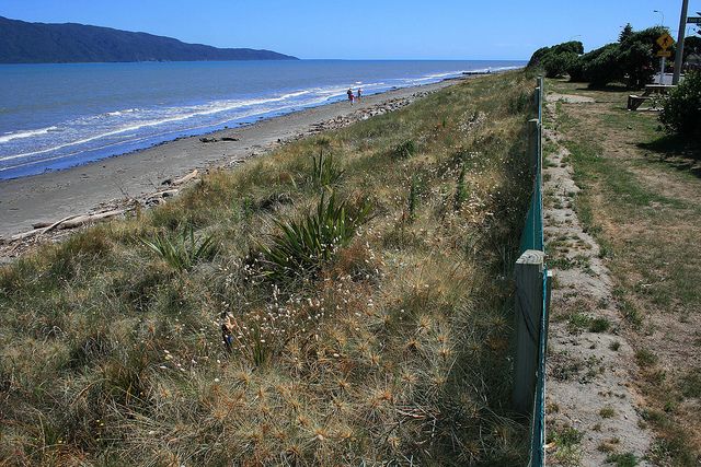
Example: Kapiti Coast district Council
As part of the coastal strategy, the district council has prepared information for users on beach access points.
Kapiti Coast (Credit: Raewyn Peart)
(2) Develop appropriate objectives, policies and rules relating to esplanade reserves
The objectives, policies and rules that are concerned with the provision of esplanade reserves and strips in district plans are a key mechanism available to local authorities to enhance public access to and along the coastal marine area when land is subdivided.
Rules should provide that the presumption of an esplanade reserve of 20 metres in width for allotments less than four hectares should only be waived in exceptional circumstances
Develop resource consent criteria to improve the provision of access walkways, reserves and esplanade strips
Territorial authorities should consider setting aside an esplanade reserve of a width greater than 20 metres in areas where there are cliffs or other physical features that result in a 20 metre strip not providing physical access. This may be appropriate where, for example there is a locally significant area that is highly valued by the public but is currently inaccessible
Territorial authorities should also consider whether an esplanade reserve should be required when allotments of four hectares or more are created (with required compensation to the landowner provided for)
Example: Hot Water Beach, Thames-Coromandel District
A plan to redevelop the Hot Water Beach campground included subdividing the land that adjoined the Taiwawe Stream into seven residential lots. Normally such a proposal would require the provision of a 20 metre wide esplanade reserve. However the developer sought to reduce this to seven metres, in some places, to increase the size of the sections.
250479ad-88c6-412b-8236-0a22dede6d78
The reduction was agreed to by the Thames-Coromandel District Council and the Department of Conservation. The issue over loss of public access opportunity through the reduction of the esplanade reserve width was taken to the Environment Court by the Tairua Environment Society and the Environmental Defence Society. As a compromise, the developer proposed to replant the riparian areas and to provide a public walkway. The Court was concerned about the viability of the planting and required the full 20-metre wide reserve to be provided.
(3) Develop appropriate objectives, policies and rules to restrict public access
The NZCPS 2010 indicates that restrictions on public access should not be imposed lightly, but they are important where key natural values are at risk. This includes where there are likely to be impacts on ecological systems or indigenous flora or fauna, as well as sites of significance to tangata whenua. In particular, restrictions must be considered where there is conflict between vehicle access to the coast and protecting such values.
Restrict public access in areas with important natural values or with high ecological sensitivity
Identify locations where vehicle access is prohibited because it is likely to negatively impact on important environmental or public values
Identify on planning maps places where public access is prohibited
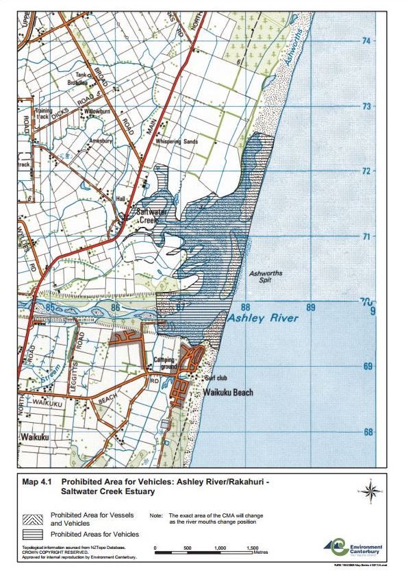
Example: Canterbury Regional Coastal Environment Plan
The Canterbury Regional Coastal Environment Plan includes a map of areas prohibited for use by vehicles in the Ashley-Rakahuri/Saltwater Creek Estuary. By identifying on planning maps these locations, people become more aware of where access is not permitted.
Prohibited Area for Vehicles: Ashley River/Rakahuri - Saltwater Creek Estuary (Credit: Environment Canterbury)
(4) Support non-statutory planning tools which promote public access to the coast
There are a number of other tools which can be used to promote public access to the coast, rivers and lakes. These include developing funding criteria.
Provide financial and other incentives for landowners to provide reserves and other access points on their land
Provide support for the establishment of beach care and coast care restoration groups, which are often involved in enhancing safe public access
Adequately fund the maintenance and enhancement of council-owned reserve land to ensure public access is maintained
Provide clear signage for c reserve land and public access ways
Prepare an access strategy to provide a more coordinated and strategic approach to developing or managing access
Involve tangata whenua, landowners, and access users in the development of key actions to enhance access
Example: Far North District Council coastal land purchase fund
The Far North District Council has set up a $4 million fund to enable the purchase of coastal land over five years for the purpose of improving public access. The Council has adopted standard criteria that will make the process of acquisition of coastal land during subdivision of coastal areas much easier and far more consistent. It is hoped that this will also result in more reserves being bought in the future.
Best practice design elements
Development design which maintains and enhances public access can include:
(1) Provide effective public access
It is important to provide effectual public access as an integral part of a development:
Ensure access points are well marked
Maintain access land to facilitate pedestrian passage (such as through providing formed pathways or regularly mowing grass)
Restrict vehicle access to only that which is necessary
Ensure all potential hazards for walking over private land are clearly identified
Where is it not practical to provide an esplanade reserve or strip right along the coastline, river boundary or lake boundary of the property, provide for public access in other ways, such as through the provision of a reserve on part of the property
Voluntary agreements are an important tool for improving public access over private land and are often much valued by the local community. However, these voluntary agreements can be undermined when ownership changes hands, so should be formalised on the land title where possible
Require developments to have public rather than private access roads
Incorporate a number of potential access points through coastal developments
Support communities’ enjoyment of the coast, rivers and lakes with appropriate education
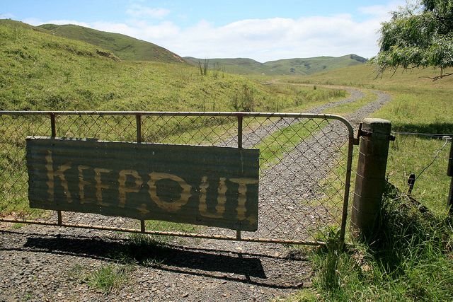
Undesirable example: Opito Bay, Thames-Coromandel District
The owners of this coastal farm have excluded public access to part of the coast.
Opito Bay Keep Out (Credit: Raewyn Peart)
Desirable example: Bream Tail, Kaipara district
The developers of this land have made provision for a public walkway around the coastal edge of their property.
Bream Tail Track (Credit: Raewyn Peart)
(2) Minimise encroachment into coastal reserve areas
Ensure that private buildings, structures and plantings do not encroach on reserve areas, or create an impression that the public is imposing on the adjacent owners’ private land.
Locate buildings well back from the boundary
Locate living areas on an upper level rather than at the eye-level of a passer-by
Clearly demarcate the edge between public and private areas
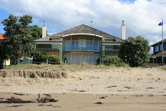
Undesirable example: Manly Beach, Whangaparaoa Peninsula, Auckland
This imposing house is located very close to the beachfront, dominating the public space.
Manly Beach House (Credit: Raewyn Peart)
Desirable example: Tutukākā Harbour, Whangarei district
Houses set back from the coastal edge, and fencing and plantings on the privateproperty boundaries, create a clearer delineation between private and public space.
Tutukaka Rocky Bay (Credit: Raewyn Peart)
Section 6(d) RMA
Section 230 RMA
Section 77 RMA
Section 229 RMA
Tairua Environment Society Inc and Environmental Defence Society Inc v Thames-Coromandel District Council and Wolfe A97/2004