Mechanisms to protect marine areas
There are many types of spatially-defined marine areas, which can be created under statute in New Zealand, and which may constitute marine protected areas. These include marine reserves, marine mammal sanctuaries, areas closed to selected fishing methods, marine parks, areas established under special legislation, areas of significant conservation value, areas to be avoided by shipping and cable exclusion areas. These mechanisms are summarised in Figure 6.x and described in more detail in the following sections.
Traditionally, Māori used the temporary closures of rāhui, mātaitai and taiāpure to manage fisheries resources. While there is some overlap between the effect of rāhui and marine protected areas, their approach and purpose differs. Fully protected marine reserves impose permanent closures to fishing in order to protect biodiversity in the long-term. Rāhui imposes a temporary closure to assist with the replenishment of kaimoana stocks so that they can be harvested in the future. As a result of these differences, proposals to establish marine protected areas can run into conflicts with manawhenua who wish to continue to exercise traditional customary fishing rights.
The following table provides an overview of mechanisms to spatially protect marine areas:
Type of Protection | Key Features |
|---|---|
| Marine reserves Marine Reserves Act 1971 |
|
| Marine mammal sanctuaries Marine Mammals Protection Act 1978 |
|
| Area-based fisheries restrictions Fisheries Act 1996 |
|
| Areas of significant conservation value Resource Management Act 1991 |
|
| Areas to be avoided by shipping Maritime Transport Act 1994 |
|
| Protected areas Submarine Cables and Pipelines Protection Act 1996 |
|
| Special legislation |
|
The following map shows New Zealand's marine reserves and marine protected areas in each coastal marine biogeographic region.
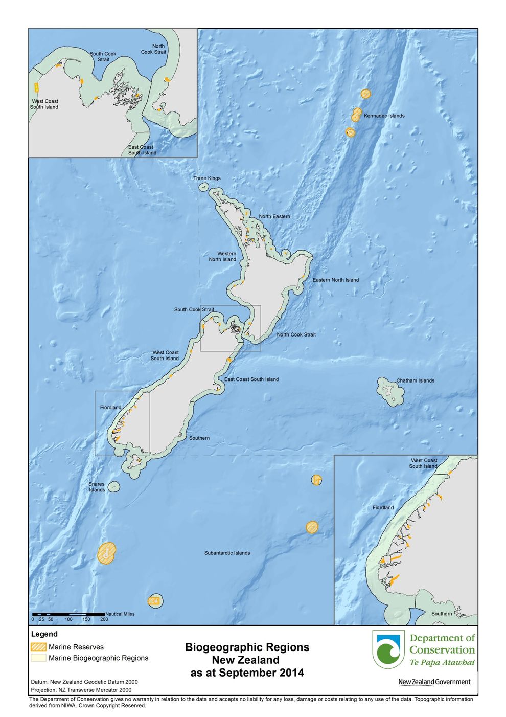
The following table represents the area of marine reserves and marine protected areas in each coastal marine biogeographic region. Note that the blank grids indicate no marine protected areas are present in the region.
|
Biogeographic Region |
Total Area (km2) of Marine Reserves |
Total Area (km2) of Type 2 MPAs |
|
Chatham Islands |
|
|
|
East Coast South Island |
|
|
|
East Coast North Island |
29 |
|
|
Fiordland |
104 |
378 |
|
Kermadec Islands |
7,480 |
|
|
North Cook Strait |
30 |
241 |
|
North Eastern |
89 |
898 |
|
Snares Islands |
|
|
|
South Cook Strait |
39 |
139 |
|
Southern South Island |
11 |
88 |
|
Subantarctic Islands |
4,980 |
|
|
Three Kings |
|
|
|
West Coast South Island |
|
|
|
West Coast North Island |
32 |
329 |
|
Total |
12,796 |
2,073 |
Marine reserves
Highly protected areas, called marine reserves, can be established in New Zealand under the Marine Reserves Act 1971. These can only be created within the territorial sea.
The purpose of establishing marine reserves under the Act focuses on scientific study rather than preserving biodiversity. The long title of the Act states that it is ‘An Act to provide for the setting up and management of areas of the sea and foreshore as marine reserves for the purpose of preserving them in their natural state as the habitat of marine life for scientific study.’
Marine reserves are managed by the Department of Conservation with the aim of maintaining them as far as possible in their natural state. Section 3(3) of the Act provides that no person shall fish in a marine reserve unless specifically authorised. This means that they are usually “no-take” areas. Other activities which could damage or remove features are also excluded. Boating, swimming and diving are usually permitted. The Marine Reserves Regulations 1993 apply to activities in marine reserves and address diving, anchoring, the use of vessels and scientific study within reserves.
Although non-commercial fishing can legally be permitted in a marine reserve, it is only currently permitted within a small part of the Kapiti Marine Reserve and is restricted to whitebaiting.
Schedule 4 of the Crown Minerals Act 1991 specifically excludes mining activity from marine reserves (those declared a marine reserve under section 4(1) of the Marine Reserves Act 1971).
An application to establish a marine reserve can only be made by a range of specified applicants, those being a university, a body administering a reserve adjacent to the coast, an organisation involved in the study of marine life and natural history, iwi or hapū with tangata whenua status over the area and the Director-General of Conservation. A significant proportion of marine reserves have been proposed by external applicants, including New Zealand’s first at Cape Rodney-Okakari Point which was proposed by the University of Auckland.
A marine reserve may not be established if it would:
- Unduly interfere with any interest in land in or adjoining the reserve
- Interfere unduly with any existing right of navigation
- Interfere unduly with commercial fishing (within the broader marine area – commercial fishing will almost always be excluded from the marine reserve area itself)
- Interfere unduly with or adversely affect any existing usage of the area for recreational purposes
- Otherwise be contrary to the public interest.
The process to establish a marine reserve is as follows:
- An application to create a marine reserve is lodged with the Director-General of Conservation
- Notice of intention to apply to create a marine reserve must be publicly notified in a range of newspapers
- Notice in writing of the application must also be given to owners of land adjoining the proposed reserve and other public bodies
- Members of the public have two months in which to lodge a written objection to the proposal with the Director-General of Conservation
- The applicant is given three months to answer the objections in writing
- The Director-General forwards the objections and answers received to the Minister of Conservation
- The Minister of Conservation decides whether any objection should be upheld. If the objection is upheld the marine reserve cannot be declared.
- The Minister of Conservation then decides if the reserve would be in the best interests of scientific study, if it would be for the benefit of the public and if it would be expedient. There are no appeal rights against the Minister’s decision although it can be judicially reviewed.
- If the Minister decides to create the marine reserve, concurrence is sought from the Ministers of Transport and for Primary Industries
- If concurrence is granted the Minister of Conservation recommends that the Governor-General makes an Order-in-Council creating the reserve
A list of current and proposed marine reserves, and information about them, can be found at the Department of Conservation’s website.
17c58a8a-33b8-40aa-86c1-d78d0b410b86
Government has initiated reform discussions about the marine protected areas framework, which, if implemented, is likely to result in new legislation replacing the Marine Reserves Act and which will enable the creation of several types of marine protected areas (rather than just marine reserves) and improve the process for their creation 8a3371b7-f5b0-430f-a565-babb7ac0dd36
Marine mammal sanctuaries
Marine mammal sanctuaries can be established under the Marine Mammals Protection Act 1978. The purpose of the Act as set out in the long title is the “protection, conservation, and management of marine mammals within New Zealand and within New Zealand fisheries waters”. The sanctuaries are managed by the Department of Conservation.
Marine mammal sanctuaries are created by the Minister of Conservation declaring the sanctuary by notice in the Gazette. The consent of other Ministers must also be obtained if they control any Crown-owned land, foreshore, seabed, or seawater. Within 28 days after publication of the notice, members of the public may lodge written submissions with the Minister, who may vary, redefine or abolish the sanctuary after considering the submissions. The Minister may specify restrictions on activities that may take place in the sanctuary at the time the declaration is made. Activities which have been controlled in marine mammal sanctuaries including fishing, mining and seismic surveying.
Area-based restrictions on fishing activity
Areas can be closed to specified types of fishing activity by the Minister of Fisheries, under the sustainability provisions of the Fisheries Act 1996, after taking into account the effects of fishing on any stock and the aquatic environment. Before making a decision to restrict or prohibit fishing in an area, the Minister must consult with stakeholders, and take into account any conservation or fisheries services and any relevant fisheries plan.
The process to impose a restriction on fishing activity will normally include the following steps:
- The Ministry for Primary Industries will prepare an Initial Position Paper
- The paper is publicly released and written submissions called for. Any person is able to make a written submission
- Once the submission period has closed the Ministry summarises and considers the written submissions and prepares a Final Advice Paper
- The Final Advice Paper is forwarded to the Minister who makes a final decision. The decision is recorded in a short letter which sets out the decision and the reasons for it.
- The decision is then given effect to, either through a notice in the Gazette or by regulations promulgated under section 298 of the Fisheries Act
There are no appeal rights, but the decision can be judicially reviewed in the High Court.
Numerous area-based restrictions have historically been placed on fishing activities, particularly in harbours and coastal areas. Many of these were not originally intended to provide marine biodiversity benefits, but were put in place to deal with issues such as conflicts between recreational and commercial fishers. They may, however, in practice result in improvements in biodiversity. More recently, restrictions under the Fisheries Act have closed 17 areas around and over seamounts (and other bathymetric features) and 17 large benthic protection areas (primarily) within the EEZ to dredging and trawling activity as a result of biodiversity concerns. These areas cover around 30 per cent of the EEZ which equates to more than four times the area of New Zealand’s landmass.
Marine parks
Two marine parks were established under the now repealed Harbours Act 1950 and regulations under the Fisheries Act 1996. These are the Tawharanui Marine Park in the northern part of the Auckland region and the Mimiwhangata Marine Park near Whangarei. The Tawharanui Marine Park was declared a marine reserve in 2011. The fisheries regulations, which apply to the Mimiwhangata Marine Park, exclude all commercial and some recreational fishing. A third marine park was set up around the Sugar Loaf Islands off New Plymouth (which is now the Sugar Loaf Islands MPA – see further discussion below).
A fourth marine park has been established under its own special legislation, the Hauraki Gulf Marine Park Act 2000. This, amongst other things, establishes the Hauraki Gulf Marine Park which primarily consists of reserve land, Ramsar wetlands, foreshore and seabed owned by the Crown, marine reserves and seawater (but not marine life). Provisions in the legislation provide for council-owned and privately-owned reserve land to be added to the marine park with the consent of the owner. Taiāpure and mātaitai reserves may also be added to the Park with the consent of the Minister for Primary Industries and the committee of management or tangata whenua.
Anyone administering an area within the Park must recognise and give effect to its purpose which is:
- To recognise and protect in perpetuity the international and national significance of the land and the natural and historic resources within the Park
- To protect in perpetuity and for the benefit, use, and enjoyment of the people and communities of the Gulf and New Zealand, the natural and historic resources of the Park including scenery, ecological systems, or natural features that are so beautiful, unique, or scientifically important to be of national significance, for their intrinsic worth
- To recognise and have particular regard to the historic, traditional, cultural, and spiritual relationship of tangata whenua with the Hauraki Gulf, its islands and coastal areas, and the natural and historic resources of the Park
- To sustain the life-supporting capacity of the soil, air, water, and ecosystems of the Gulf in the Park
The legislation also establishes the Hauraki Gulf Forum and provides a set of management objectives which apply to the Gulf’s coastal marine area, islands and catchments. These are described more fully in Chapter Two.
Areas protected by special legislation
Some areas are protected by other special legislation, which is tailored to each case, and does not have more general application. The Sugar Loaf Islands Marine Protected Area Act 1991 establishes the Sugar Loaf Islands Marine Protected Area covering an area of eight square kilometres. The protected area is managed by the Department of Conservation. Mining is prohibited in the protected area and there are also restrictions on fishing activities under the Fisheries Act.
The Fiordland (Te Moana o Atawhenua) Marine Management Act 2005 establishes a Fiordland (Te Moana o Atawhenua) Marine Area, which encompasses the waters from Awarua Point on the South Island’s West Coast (40 km north of Milford Sound) to Sandhill Point on the South Island’s south coast, and to 12 nautical miles off the coast and in which a total of 103 square kilometres of inner fiord marine habitat are currently protected in marine reserves. Unlike the case for the Hauraki Gulf, the Fiordland legislation does not establish any common management objectives for the marine area. Instead, a collective vision, namely “... that the quality of Fiordland’s marine environment and fisheries, including the wider fishery experience, be maintained or improved for future generations to use and enjoy”, has been developed by the Fiordland Marine Guardians, guiding the drafting of the ‘Fiordland Marine Conservation Strategy’. The Fiordland Marine Guardianshas an advisory and facilitative role, amongst other things, and is responsible for sharing information which will benefitinthe ongoing management of the Area. The Guardians receive management and administrative support from the Ministry for the Environment. Members of the Guardians are appointed by the Minister for the Environment with a requirement that one member be nominated by Te Rūnanga o Ngāi Tahu, that at least five members are ordinarily resident in the Otago or Southland regions, and that the membership reflects a balanced mix of knowledge and experience in relation to the Marine Area. The Department of Conservation has a monitoring role, and the Ministry for Primary Industries oversees biosecurity matters and the sustainable use of fisheries resources.
Similar legislation now applies to Kaikōura. The Kaikōura (Te Tai o Marokura) Marine Management Act 2014 provides for the establishment of the Kaikōura Guardians who can provide advice to Ministers on matters affecting the Te Whata Kai o Rakihouia i Te Tai o Marokura—Kaikōura Marine Area which is identified in the legislation. Members of the advisory body are appointed by the Minister of Conservation and the Minister responsible for the administration of the Fisheries Act (currently the Minister for Primary Industries). The members of the advisory committee must represent certain interests and areas of expertise including Te Rūnanga o Ngāi Tahu, the Kaikōura community, biosecurity, conservation, education, environment, fishing, marine science and tourism. The Act also creates a number of MPAs and other management areas including a marine reserve, a fur seal sanctuary, a whale sanctuary, mātaitai and taiāpure.
Areas of significant conservation value
Areas of significant conservation value are sometimes spatially identified in regional coastal plans under the RMA and measures such as protective rules to ensure that these areas are not adversely affected, are specified. Usually activities such as aquaculture, marinas and moorings, reclamations and building structures are to be avoided in these areas.
Such provisions are included in regional coastal plans after a public process, which involves the public notification of the proposed plan provisions, opportunity for written public submissions, opportunity for cross submissions and then a public hearing. Decisions of the council on submissions can be appealed to the Environment Court.
It is also possible for any person to lodge a private plan change to insert provisions into regional coastal plans identifying significant conservation areas and providing for their protection. Private plan changes go through a similar process, although they can be rejected by the council on a number of grounds.
In 2016, the Environment Court confirmed that regional councils can control fishing for resource management purposes. Following the Rena grounding in 2011, the Motiti Rohe Moana Trust (Trust) sought protection of the Otaiti (Astrolabe) Reef to improve depleted fish stocks and allow taonga species to recover. The Trust applied for a declaration to say that is it lawful for the council to include objectives, policies and methods (including rules) in its proposed Regional Coastal Environmental Plan, in spatially defined parts of the coastal marine area, that avoid, limit or discourage fishing techniques or methods where the sole or dominant purpose relates to protection of biodiversity, significant habitat, natural character or the relationship of Māori with waters and taonga species. The Judge made the declaration.
Section 32(2) of the RMA states that Regional Coastal Plans cannot, “control the taking, allocation or enhancement of fisheries resources for the purpose of managing fishing or fisheries resources controlled under the Fisheries Act 1996”. 24d76650-b6b4-4622-aa1c-315493248d0e The court described the section as “particularly limited” in its effect and for the section to apply a proposed rule would need to be for a function under section 30(1)(d)(i), (ii) and (vii), control the taking, allocation or enhancement of fisheries and be for the purpose of managing fishing or fishing resources. The court found that section 32(2) may be a matter to be had particular regard to as part of the assessment of the merits of provisions in a plan, rather than a limit on its jurisdiction. 85c502ca-baa9-4934-a2db-e706e5b6ff03
Areas to be avoided by shipping
Areas to be avoided by shipping can be established under the Maritime Transport Act 1994 through marine protection rules within the umbrella of the International Maritime Organisation. There are three categories of such areas: recommended areas to be avoided; mandatory areas to be avoided; and particularly sensitive areas.
New Zealand has mandatory areas to be avoided around the Three Kings Islands and Poor Knights Islands, which means that ships in transit are prohibited from entering the areas. In the case of the Poor Knights Islands, the restriction applies to every ship of more than 45 metres in length, except for fishing vessels and barges under tow (so long as their cargo does not include oil or other harmful liquid substances). The restrictions around the Three Kings Islands apply to all ships of 500 gross tonnes or more.
The following process is followed to develop a new marine protection rule, or to amend an existing rule:
- Maritime New Zealand prepares a draft rule and undertakes informal consultation
- An invitation to provide written comment on the rule is advertised widely to the maritime community and general public
- Maritime New Zealand considers the written comments and prepares a revised rule which may be circulated to key stakeholders for comment before finalisation
- The Minister of Transport approves the rule and it is notified in the Gazette (section 448).
Cable protection areas
Protected areas can be declared under section 12 of the Submarine Cables and Pipelines Protection Act 1996. All fishing operations and anchoring are prohibited in such areas. This exclusion is not for environmental purposes, but is intended to protect cables and pipelines from damage. However, it may have the indirect effect of restricting activities which could also impact on biodiversity within the area.
Wildlife management reserves
These are established under the Wildlife Act and can potentially extend into the marine area. Can DOC please advise if any wildlife management reserves apply to the marine area, and if not why not.
The Westhaven (Te Tai Tapu) Marine Reserve is adjacent to the Westhaven (Whanganui) Wildlife Management Reserve. Effectively the estuary at Westhaven is therefore protected both as marine reserve and as a wildlife reserve. The marine reserve covers 536 hectares of tidal sandflats and channels within Whanganui Inlet, on the western coast of Golden Bay, and the wildlife management reserve covers over 2112 hectares of tidal sandflats and channels not included in the marine reserve. feefb4f6-9e94-48c3-b452-5182def9b830
Case study: Hector's and Māui dolphins management plan
The Hector’s dolphin is typically found off the coast of the South Island. It is classified as Nationally Vulnerable in the New Zealand Threat Classification System, with an estimated population of 15,000 individuals. The Māui dolphin, a subspecies of Hector’s dolphin, is found off the northwest coast of the North Island. It is classified Nationally Critical with an estimated population of 63 individuals remaining.
In 2007/08, in response to concern about the effect of human-induced deaths of these dolphins, the Government developed the Hector’s and Māui Dolphin Threat Management Plan (TMP). The Māui dolphin component of the plan was reviewed in 2012 and the whole plan was reviewed in 2019/20.
The plan’s vision is that the dolphin populations are resilient and thriving throughout their natural ranges. It identifies human-induced threats to the dolphins and sets out strategies to mitigate those threats to ensure the dolphins’ long-term survival.
The Department of Conservation (DOC) and Fisheries New Zealand are responsible for implementing the TMP. DOC manages the dolphins’ populations, while Fisheries New Zealand manages the effects of fishing-related mortality.
The TMP sets out two types of protection measures: fishing protection measures and non-fishing protection measures. The TMP is a non-statutory document, but its protection measures are implemented via regulation.
The fishing protection measures include extensive restrictions on where trawl and set net gear can be operated, monitoring requirements and a fishing-related mortality limit as follows:
- Restrictions to commercial and recreational set-net and commercial trawl fishing off the west coast of the North Island and off the north, south and east coast of the South Island.
- Prohibition of commercial drift netting in all New Zealand waters.
- Establishment of a fishing-related mortality limit applying to recreational and commercial fishers. The fishing-related mortality limit for Hector’s or Māui dolphins within the defined Māui dolphin habitat zone (west coast of the North Island from Cape Egmont to Cape Reinga) is set at one individual. So if a single dolphin is caught in this area the Minister for Oceans and Fisheries can impose conditions including prohibiting fishing in an area. a546dfcd-37f5-4ff7-ae86-31d89b789815
- Fishing monitoring requirements such as the installation of on-board cameras on commercial fishing vessels.
These protection measures are implemented under the Fisheries Act 1996 and Fisheries Regulations. They are supported by a Bycatch Reduction Plan which includes a suite of voluntary and regulatory measures (i.e., fishing-related mortality limits and on-board camera monitoring) ccb632bd-a3f4-459b-848d-8751432ef96f to incentivise fishers to reduce Hector’s dolphins’ bycatch towards zero.
Non-fishing protection measures include:
- A Toxoplasmosis d495d247-8037-4083-889f-221c93f545c4 action plan to research knowledge gaps and investigate solutions to reduce or eliminate the transfer of Toxoplasma parasites into the marine environment.
- Establishment of five Marine Mammal Sanctuaries under the Marine Mammals Protection Act 1978. Seismic surveying and seabed mining is generally prohibited in the sanctuaries. The total coverage of the five sanctuaries amounts to 37,286 square kilometres.
- Managing tourism through permitting conditions applied under the Marine Mammals Protection Regulations 1992.
These protection measures are implemented under the Marine Mammals Protection Act 1978 and Marine Mammals Protection Regulations 1992.
The TMP also acknowledges other non-fishing threats, such as oil spills, pollution or sediment run-off, coastal development and climate change. These threats are managed under other regulatory regimes, including the RMA, the Exclusive Economic Zone and Continental Shelf (Environmental Effects) Act 2012 and the Marine Mammals Protection Regulations 1992.
-
http://www.doc.govt.nz/conservation/marine-and-coastal/marine-protected-areas/marine-reserve-information/
-
https://www.national.org.nz/docs/default-source/PDF/2014/policy/conservation-policy.pdf
-
http://www.doc.govt.nz/parks-and-recreation/places-to-visit/nelson-tasman/golden-bay/westhaven-reserves/
-
Section 30(2), RMA.
-
Motiti Rohe Moana Trust v Bay of Plenty Regional Council [2016] NZEnvC 240 at 32.
-
Fisheries Act 1995, s 15
-
https://www.mpi.govt.nz/dmsdocument/53752-Protecting-South-Island-Hectors-Dolphins-fact-sheet
-
Toxoplasmosis is a disease produced by parasites originating in cats, that spreads to the sea through terrestrial run-off.
Last updated at 10:03AM on January 22, 2025